


montagne du Taconnaz

GeRv
User
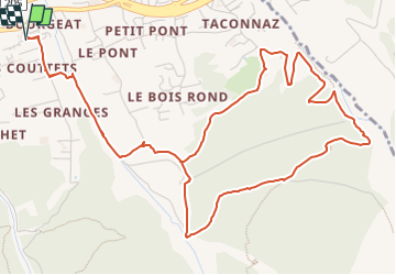

Length
7.6 km

Max alt
1419 m

Uphill gradient
487 m
Km-Effort
14 km

Min alt
1002 m

Downhill gradient
487 m
Boucle
Yes
Creation date :
2022-08-03 09:17:02.348
Updated on :
2022-08-03 09:21:50.54
3h11
Difficulty : Difficult

FREE GPS app for hiking
 SityTrail
IGN / Geographical institutes
SityTrail Plus
The world is yours!
About
Trail Walking of 7.6 km to be discovered at Auvergne-Rhône-Alpes, Upper Savoy, Les Houches. This trail is proposed by GeRv.
Positioning
Country:
France
Region :
Auvergne-Rhône-Alpes
Department/Province :
Upper Savoy
Municipality :
Les Houches
Location:
Unknown
Start:(Dec)
Start:(UTM)
330095 ; 5084756 (32T) N.
Comments